Multi-Sensor Core Logger (MSCL-S)

Standard Multi-Sensor Core Logger (MSCL-S)

Multi-Sensor Capability

Geotek’s standard Multi-Sensor Core Logger (MSCL-S) is recognised as a crucial step in many geological coring workflows, including those for palaeoclimate, mineral exploration, geometallurgy, oil and gas, nuclear or geotechnical. The MSCL-S operates by automatically moving core samples past a series of sensors. The MSCL-S benefits from a modular configuration allowing for a range of petrophysical and geochemical sensor technology to be integrated onto one core scanning system, producing a single depth co-registered data set. 

The MSCL-S may accept either whole/split unconsolidated sediment cores in liners, or whole/slabbed rock cores with or without a liner. Depending on the requirements of the project, each MSCL-S system can be setup to take depth co-registered measurements for each sensor between 1 mm and 100 mm intervals downcore with a position accuracy of better than 0.1 mm. Furthermore, if new technology becomes available, or research focus changes, the MSCL-S system can be upgraded with new sensors to ensure longevity of the scanning system.

The MSCL-S is field-proven with Geotek and many of our customers routinely installing their core scanner in remote onshore locations, or offshore laboratories aboard ships or platforms. Geotek can also provide containerised laboratory solutions for customers.

Set up for a variety of core types

The MSCL-S accepts nearly any form of core material, including whole or split rock core samples and whole or split unconsolidated sediment samples in plastic or metal liners. The system is capable of logging core sections of up to 1.55 m with a maximum diameter of 150 mm.

  • Whole Lined Sediment Core

    • Data acquired through plastic or metal-lined cores

  • Split or Slabbed Cores

    • Accepts split sediment cores or slabbed rock cores

  • Whole Unlined Rock Core

    • Samples are pushed through the system on stabilising core trays for continuous logging

Unlock the full value of your core material

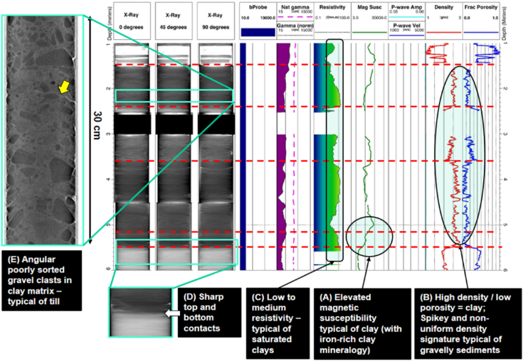
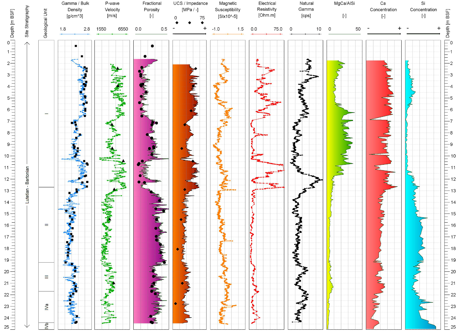
The simultaneous and depth co-registered acquisition of multi-sensor data provides the perfect foundation for the analysis of geological stratigraphy, and to uncover parametric relationships that define different geological units that might have previously been hidden or unidentified.

Whilst each individual dataset is equally valuable, the real advantage of acquiring multiple parameters is the ability to correlate between disparate data sets and deliver integrated vertical downcore profiles to aid in the identification of core lithology, heterogeneity, and facilitate analytical data comparisons of materials between core locations or between core and downhole data. 

Importantly, MSCL-S data acquisition is entirely non-destructive and creates a permanent digital archive for future reference, permitting the investigation of archived core material or core material that is scheduled for future destructive testing.

Applications

previous arrow
Core repositories
Core Repositories

Archived core material is an enormous reservoir of potentially valuable data which is often underutilised. Archived cores can be digitised using MSCL-S technology.

In this example we showcase MSCL-S data acquired from core originally drilled in 1985 from the Dunlin Field in the UKCS. The MSCL data firstly correlated with the existing sedimentological logs but also identified new, previously undescribed facies. This example highlights how much data can be rescued from archived core, which can then be used, confidently, to bolster new datasets and ultimately understand the reservoir or geological stratigraphy in enhanced detail without the requirement to acquire new core material.

Marine Geology
Marine Geology

Acquisition of physical and geochemical datasets from marine sediments, either whole or split cores, in plastic or metal liners, is often fundamental to the understanding of these deposits. MSCL-S data is able to detect a range of subtle sedimentary changes such as clay/sand discrimination, mass movement deposits, deepwater crusts, unconformities, and many more. In this example we present an unconsolidated marine sediment core from the Black Sea. Density, ultrasonic P-wave velocity (Vp), magnetic susceptibility and electrical resistivity were acquired every 1 cm before splitting the cores allowing for key stratigraphy to be identified ahead of cutting. Once split, the MSCL-S was used to acquire core images, colour and XRF datasets. The MSCL-S data was critical for the selection of subsamples for future analyses. Additionally, when non-destructive MSCL-S data is acquired offshore, it can be used to drive a flexible coring strategy, maximising precious ship time.

The downcore profiles show the typical stratigraphy of the Black Sea including the characteristic Sapropel horizon between 0.5 m and 1.0 m, which is used as an age and depositional marker across the region.

Engineering Geology
Engineering Geology

Multi-sensor core logger scanning coupled with X-ray imaging, using a Geotek XCT, are non-invasive methods that can safely be used on contaminated cores or cores that are wholly dedicated for other analyses.

In this example from the Sellafield nuclear site, we show how the physical characteristics of radioactively-contaminated cores were used to identify their geological contents and use them to update an existing stratigraphy without opening the core liners and visually describing the core.

The hydrology at the Sellafield location, as at many industrial sites, must be understood to minimize the environmental impact of the industrial use. The geophysical data from the MSCL-S & XCT study was used within a three-dimensional model of the geological site and refined the lithological units that constrain the local groundwater flow.

Read the full paper here and explore the characteristics of meltwater facies also identified within the site and the implications to the Sellafield Nuclear Site.

MSCL and X-ray characteristics of clay-rich diamicton (till) lithologies within BH7 (1 m–6 m BGL

Smith, N., Shreeve, J., Kuras, O. (2020) Multi-sensor core logging (MSCL) and X-ray computed tomography imaging of borehole core to aid 3D geological modelling of poorly exposed unconsolidated superficial sediments underlying complex industrial sites: An example from Sellafield nuclear site, UK. Journal of Applied Geophysics 178 https://doi.org/10.1016/j.jappgeo.2020.104084

Oil and Gas
Oil and Gas
Downhole measurements and MSCL downcore measurements combined and depth corrected to the borehole image. Data were acquired on archived core acquired in 2009 to investigate if borehole breakouts are a function of lithology, core microfabic, or regional stress regime. The high resolution nature of the MSCL data show how coarse some downhole datasets can be, and how much additional information is locked within the core material.

Fellgett MW, Kingdon A, Waters CN, Field L, Shreeve J, Dobbs M and Ougier-Simonin A (2019) Lithological Constraints on Borehole Wall Failure; a Study on the Pennine Coal Measures of the United Kingdom. Front. Earth Sci. 7:163. doi: 10.3389/feart.2019.00163

The understanding of sediment and rock properties and their effect on reservoir assessment can be significantly improved through the use of continuous downcore scanning.

This example shows depth co-registered MSCL measurements combined with previous wireline data from the Melbourne 1 Borehole. The study aimed to highlight small compositional changes of a paleosol unit and test whether borehole breakouts were a function of lithology, core micro-fabric or regional stress regime. Although not indicated in the wireline data, the physical properties acquired through the high-resolution MSCL indicated the presence of coal seams. The MSCL scanning highlighted significant variation in mineralogy, proving that a breakout occurred within the upper part of the paleosol and terminated an iron-rich unit in the lower part of the paleosol. The use of core scanning in this way has significantly improved the geological characterisation of the Melbourne 1 borehole and helped to maximise the value of the core samples.

Mining
Mining

Drill cores are a crucial part of any exploration program and mining chain evaluation. However, physical properties and geochemistry are often acquired separately using discrete methods of measurement or on different platforms. Here in this example from the Pary’s Mountain mine in the UK we show a high resolution (1cm) density and ultrasonic P-wave velocity (Vp) profile combined with depth co-registered geochemistry. Measurement intervals between points can be increased to 5 cm or 10 cm, enabling higher throughputs to characterise deposits for geometallurgy or geotechnical studies.

Geotechnical
Geotechnical
Geotechnical Data Example

Shreeve J, Shreeve B, Pitel J, Palix E, and Souf A (2017) The use of non-destructive core logging and X-ray imaging techniques to resolve a complex geological stratigraphy for a planned offshore windfarm

Continuous multi-sensor core logging (MSCL) and X-ray imaging techniques illuminate the geological stratigraphy that determines foundation selection. The non-destructive data set allows selection of representative samples and forms a framework for field and laboratory geotechnical test data.

This example illustrates how much additional data is acquired through multi-sensor core logging, compared with conventional laboratory testing alone (black measurement points), though the two data sets are congruent. The continuous profiles of geochemical and geophysical parameters allowed easy separation of the core data into a five geological units that were then assigned across the windfarm site. The resultant confidence from the MSCL logging meant it was possible to predict the location of the strong, dense calcarenite which had implications on the foundation installation method.

PlayPause
next arrow
  • Specifications

    • Core accepted: Length: up to 155 cm; Diameter: up to 15 cm
    • Compatible sensors: gamma density, P-wave velocity (Vp), shear wave velocity (Vs), electrical resistivity, magnetic susceptibility (loop and point sensors), natural gamma spectroscopy, line-scan imaging, colour spectrophotometry, X-ray fluorescence, infrared spectroscopy
    • Core motion: Fully automated motion. Linear precision: 0.01 mm
    • Data output: Tab-delimited ASCII files containing all measured parameters vs. depth in section and core
    • Track dimensions: Length: 5 m; Depth: 1.2 m; Height: 1.15 m (1.9 m with camera); Weight: c. 500kg
    • Electronics rack dimensions: Length: 0.55 m; Depth: 0.6 m; Height: 0.6 m; Weight: 65 kg
    • Scan speed: Typical logging speed 4 m/hr
    • Data collected from all sensors simultaneously, displaying co-registered data sets in real time.

Other Configurations

The MSCL-S is a core scanning tool to which creates a systematic and semi-automated workflow to extract the maximum amount of data using multiple sensors in a time-efficient and cost-efficient operation. As Geotek’s sensor technology expanded, a range of different platforms were developed to accommodate a variety of scanning projects and customer requirements. These include systems that may be dedicated to petrophysical property scanning, geochemical/spectroscopic property scanning, core imaging, hyperspectral IR imaging, scanning of core boxes, or analysis through x-ray imaging. 

Please see below for a range of different sensor configurations installed onto our systems.

For further information please contact us.