BoxScan

BoxScan Logo
previous arrowprevious arrow
Automated Multi-sensor Core Scanning

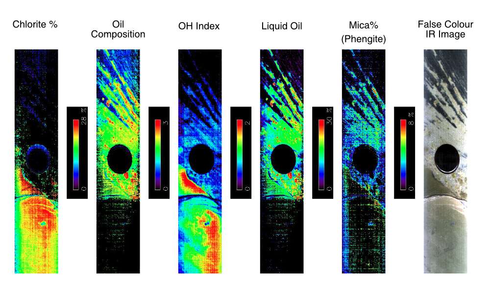
Acquire up to 6 different datasets without manipulating a sensor or the core

Field Portable
Field Deployable

Custom shipping crate with vibration protection to allow for easy and simple transportation to all corners of the globe

Core or Chip Scanning

Scanning protocols for scanning cores, rubble, chips and pulps

Core Photography without Compromise

Linescan camera technology for fast, high resolution visible or UV dry and wet core photography

Remote Installation, Training, and Troubleshooting

Online training for installation, training and field support all from Geotek’s geoscience support team

Core Curation
Core Curation Built Into The Workflow

Robust procedures for on instrument core curation of data so you get access to data in borehole depth faster and with less after scanning effort

PlayPause
next arrownext arrow

BoxScan solves the often resource-draining practicalities of acquiring laborious handheld logging measurements using pXRF, NIR, cameras, or goniometers by delivering automated and simultaneous acquisition of geotechnical and geochemical parameters from one easy to use, field deployable, core box scanning system.

Learn More about the Features of BoxScan

MODULAR AND FLEXIBLE THROUGHPUT

BoxScan is a modular core scanning platform that allows users to choose the most fit-for-purpose multi-sensor suite for their project. Through the use of dedicated acquisition software, scanning parameters for each box or even each metre of core can be amended so that frequency of measurement, type of measurement or even integration time of measurement can be optimised. As a result, the BoxScan can be set to the optimal throughput speed needed for the project.

Field Portable Core Scanning

BoxScan is small-footprint and fits in the back of a standard 2.4 m bed pick-up truck for easy transport to remote locations. Running on only standard power with no cooling required, and using rugged and reliable handheld field-based sensor technology, BoxScan is designed to operate in the field to provide near-real time results.

Remote Installation, Training and Troubleshooting

Remote location? Want to keep costs down? No problem: BoxScan can be installed remotely. Our dedicated team of experienced geoscientists and support technicians will guide you through the process of unpacking, setting up, and scanning – all remotely.

Save on Labour

Only one field technician is needed to operate BoxScan and they can acquire up to 6 different datasets without manipulating a sensor or the core, reducing disturbance of the core material and human error in the measurement.

Geoscientist using BoxScan

Automated Quality Assurance and Quality Control

BoxScan Sensors

High-quality data stems from two factors: quality assurance and quality control. To guarantee the best quality data, the BoxScan has repeatable methods and quality checks. Quality assurance is ensured by the automation of the BoxScan scanning equipment. The automation of BoxScan provides repeatable data acquisition and repeatable processing protocols. Quality control is ensured by proper calibration and check protocols, which are integral to BoxScan. QC standards have fixed locations on BoxScan to facilitate automatic measurement, as a result standards are automatically measured on a regular basis, and the resulting data is stored alongside the core data.

Core Curation and Depth Control

All data sets on BoxScan are collected in “logged depth”, which has an instrument depth frame of reference. A separate curation file, relating logged depth to borehole depth, is created using BoxScan software. This curation file is applied to all the BoxScan data files creating borehole depth data. This post-processing depth assignment can be run again at any time in the future if the curation file is updated.

BoxScan Curation Example
AreaScan Image with Core Curation Example from BoxScan

Data Output

All data acquired from each sensor is exported depth-coregistered against borehole depth in flexible, non-proprietary formats, facilitating upload into various software platforms.

BoxScan datasets can be visualised in a number of different ways, however, most typically downhole logs of the data are produced. Two examples of logs are showcased here.

Data provided courtesy of Ariana Resources.

In this case study we show an interval of data acquired over a gold and silver-rich vein. Data were acquired every 10 cm for all point measurements. Wet and dry core photographs and the RGB were acquired at c.65 µm per pixel. Interpretation of the VNIR/SWIR data was performed by aiSIRIS. Please contact sales@geotek.co.uk for a full resolution copy of this log.

Data provided courtesy of valuable customer.

In this case study we show an interval of data acquired within a PGE deposit. Data were acquired every 1 cm for all point measurements. Wet and dry core photographs and the RGB were acquired at c.65 µm per pixel. Interpretation of the VNIR/SWIR data was performed by aiSIRIS and geotechnical parameters are interpreted by Datarock. Please contact sales@geotek.co.uk for a full resolution copy of this log.

BoxScan has now been deployed to remote field locations. To gain access to the latest example datasets and examples for the mining or oil and gas industry please contact our sales team at sales@geotek.co.uk.

Flexible Finance Models

Sale Icon

Sale

Geotek offer sales of BoxScan system where users can utilise their own Olympus Vanta or Labspec sensors and integrate onto BoxScan.

Calendar Icon

Lease

Geotek have a fleet of BoxScan units situated around the world for customers to access. Contact us now to start using a system now

Service Icon

Service

Geotek have a team of dedicated geologists who are ready to travel to site to conduct the scanning for your project

Other MSCL and Imaging systems