19 Jul USGS Upgrade to the Latest XRF and NIR Sensors
Lacustrine, peat, ocean sediment and harder continental drill cores will all be analysed on the Geotek Multi-Sensor Core Logger (MSCL-S) at the United States Geological Survey’s (USGS) Florence Bascom Geoscience Center (FBGC). The MSCL forms a critical part of the analysis workflow by delivering non-destructive geophysical and geochemical data, in the effort to develop a clearer understanding of paleoflood and drought coverage across America.
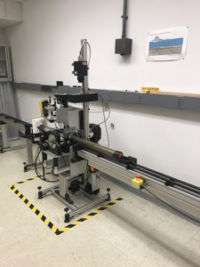
Geotek MSCL-S in the FBGC Laboratory
Installed in 2016, the MSCL-S has successfully delivered 184,000 high resolution measurements for input into natural hazard, paleoenvironment, and geological mapping research projects at the FBGC. The continuous high-resolution outputs from the MSCL-S have uncovered subtle stratigraphic changes in the geochemical and physical properties that might have gone undetected if visual inspection and discrete sampling were used alone. As part of a state-of-the-art petrophysics facility; the FBGC MSCL-S sensor array includes a GeoScan V Linescan camera, gamma density sensor, magnetic susceptibility sensor, P-wave velocity sensor and colour spectrometer, and now after a recent upgrade in 2019 an Olympus Vanta M XRF and ASD Labspec 4 VNIR and SWIR spectrometer.
Following their upgrade, the FBGC can now acquire elemental and mineralogical datasets along side those geophysical datasets. The fully automated core logging procedures are controlled through easy to use Geotek software packages, allowing sensors like the Olympus Vanta XRF to be integrated onto the MSCL platforms with ease to deliver accurate and repeatable elemental abundances alongside other MSCL sensors. Whilst each individual dataset is equally valuable, the main advantage of acquiring multiple parameters is the ability to corroborate lithological interpretations, provide a vertical profile to aid in the identification of local and larger scale sediment variations, and facilitate the correlation of lithological or physical property changes of the sediment between core locations.
 The Florence Bascom Geoscience Center will be using the MSCL-S on a range of new projects, including the scanning and imaging of sediment cores for the “Natural Drought and Flood Histories from Lacustrine Archives Project.” This specifically aims to help predict and prepare for future changes. The center is hard at work researching pivotal scientific issues to better inform governments and industries, and we are very pleased that the MSCL-S will be playing a crucial part in such an important investigation.