Multi-Sensor Core Logging

Multi-Sensor Core Logging (MSCL)

MSCL systems rapidly and non-destructively obtain high-resolution (typically 1 cm to 10 cm downcore spacing) geophysical and geochemical data from sediment and rock cores. The high quality multi-parameter stratigraphy delivered from MSCL systems enables facies classification and soil/rock typing ahead of, or in support of a visual description.  Ultimately this leads to improved laboratory test planning for any necessary destructive or advanced laboratory testing.  The Geotek core logging services team follows strict calibration procedures for each core size and liner type to ensure consistency and accuracy of data collection.

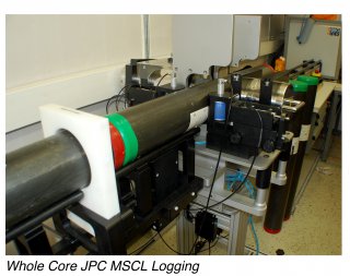
Sediment or rock cores with or without metal or plastic liners up to 1.5 m long and 155 mm in diameter can be accepted.  Physical, elemental and mineralogical properties can be obtained from whole or split/slabbed core samples regardless of whether they are within a liner or not. An MSCL dataset provides vital information about core heterogeneity or homogeneity ahead of destructive laboratory testing or visual logging.

Typical MSCL Dataset

Typical MSCL Applications

Increasingly Geotek MSCL logging services are being used to provide continuous downcore data to various different markets each for their own reasons:

Geotechnical

  • Density, porosity, and P-wave velocity profile
  • Identification of sample disturbance
  • Improved laboratory test planning
  • Determination of salinity profiles
  • Correlation with downwhole wireline data

Geophysical

  • Determination of velocity profiles to improve depth-time conversion
  • Measurements of acoustic impedance
  • Generation of synthetic seismograms

Oil & Gas/Unconventional

  • Spectral natural gamma, density and P-wave velocity measurements for core to log correlation
  • High-resolution visible and ultraviolet linescan photography
  • Chemostratigraphy using through XRF core scanning
  • Identification and quantification of core heterogeneity

Geohazard

  • Parametric characterisation of geohazard features within the core, such as: turbidites, nodules/gravels, erosion surfaces
  • Identification of geohazard features such as: gassy soils, high salinity profiles, cemented-horizons, or sand/clay-rich layers
  • Improved quantification of geological formations/units
  • Improved lateral correlation between core locations

Whole Core JPC MSCL Logging

Core Repository

  • High resolution linescan photography for cataloguing
  • Reduce initial core acquisition investment risk by improved characterisation of archived core material
  • Acquisition of petrophysical data to depth correct archived core material to downhole data

Available Sensors

Depending on the type and quality of the core samples any of the sensor technologies mentioned below can be installed onto the MSCL.

Attenuated Gamma Density

Comparable to bulk density

Estimation of porosity

Identification of core disturbance

Identification of lithological changes

Ultrasonic P-wave Velocity

Improved velocity profiles

Generation of synthetic seismograms

Link to elastic properties

Identification of cemented horizons

Magnetic Susceptibility

Identification of terrigenous material

Core to core correlation

Link to magnetic survey data / models

Identification of lithological changes

Electrical Resistivity

Proxy for pore-fluid properties

Identification of lithological changes

Derivation of geotechnical properties

Core to core correlation

Spectral Natural Gamma

Lithological interpretation

K, U, Th derivation

Core to core correlation

Core to log correlation

X-ray Fluorescence

Chemostratigraphy

Mineralogical interpretation

Derivation of mechanical properties

Core to elemental log correlation

Colour Spectrophotometry

Quantitative colour data

Munsell colour code output

Link to core mineralogy

Near Infrared Spectrometry

Identification of core mineralogy

Lithological determination

Quantification of core colour

Geoscan Camera

Incredibly detailed core surface images

UV images to identify hydrocarbons

Typical deliverables

  • Factual data report with integrated X-ray and MSCL logs provided
  • All data are delivered processed as Ascii tab-deliminated files
  • If possible, data are depth corrected

  • 16-bit linescan images provided with RGB file
  • Geotek MSCL data and linescan image viewer provided